Sunday, September 2, 2018

Goode NE Buttress + Storm King

Goode is one of the hidden giants of the Cascades, rising over a mile from the valley floor but not visible from any road. Its summit is guarded by steep walls of loose rock that repelled many attempts during the early 1930s. It was eventually climbed by Wolf Bauer, Joe Halwax, Jack Hossack, George MacGowan, and my great-grandfather Phil Dickert in July 1936. They approached from Stehekin and then climbed the south side of the mountain to the base of the fortified summit pyramid. They followed the most obvious weakness, climbing the Southwest Couloir until its walls funneled them into a steep chimney that had stymied previous parties. Wolf Bauer led the chimney, placing the first piton in the North Cascades. Fred Beckey offers a more complete description of the route in the Cascade Alpine Guide, but warns that it is "only of historical interest."

I do hope to repeat the route of the first ascent when I have time for the boat to Stehekin. For this trip, Nate and I decided to climb the magnificent Northeast Buttress of Goode then tag Storm King and continue to Logan over three days.

Goode's north face with the Northeast Buttress at center

Nate and I drove out to the Bridge Creek trailhead on Thursday night and stashed a bike at the Easy Pass trailhead along the way. We started hiking at 11pm and followed the PCT south for about 10 miles to the junction with the North Fork of Bridge Creek. We got a few hours of sleep before the sun woke us and we started hiking again.


Mama black bear. Her two cubs are nearby

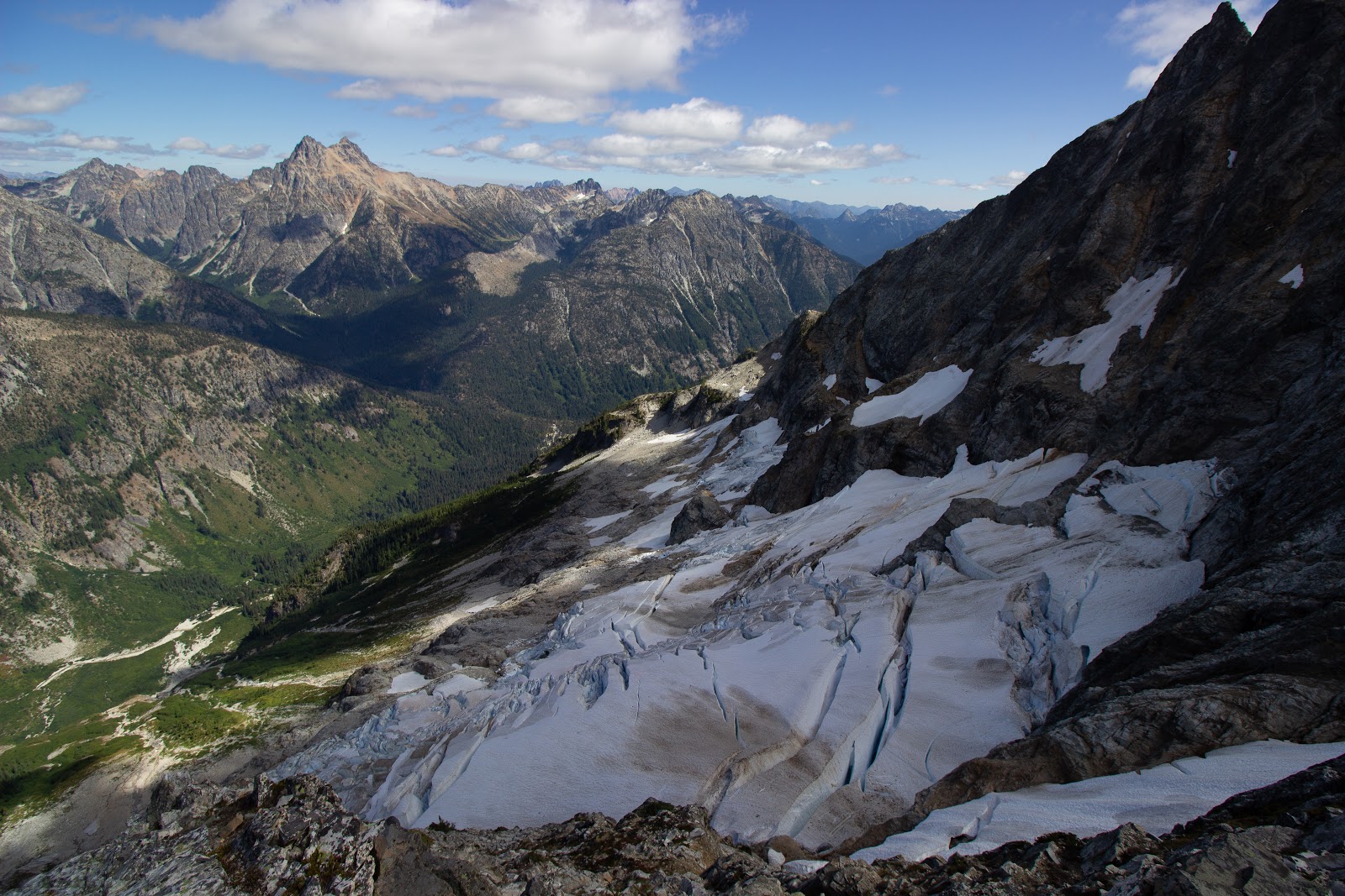
The North Fork of Bridge Creek was an easy ford this late in the season. We crossed directly below the Northeast Buttress and took a direct line up talus, granite slabs, and slide alder to the base of the Goode Glacier.

Thankful to find a path through the slide alder

The base of the Goode Glacier is a jumbled mess of seracs; a depressing sign of retreat. We traversed to the right and found a way onto the glacier via a short step of near vertical ice. I used both of our ice axes to lead the step and then passed them back down to Nate. We hadn't brought pickets or ice screws so I was unable to offer Nate a belay. He had never climbed ice before, but still crushed it!


Traversing below the Goode Glacier

Nate above the short steep step
We weaved a line thorough the broken glacier and eventually made it to the left side of the NE Buttress. A gaping moat separated us from the rock, bridged by a sliver of snow. The bridge will not be there for long, and without it gaining the NE Buttress will require an overhanging rappel into the moat. I wouldn't recommend it at this point in the season.

Next step: Cowboy Arête on the Cassin Ridge
Photo: Nate Redon


Looking back at the snowbridge that we used to gain the NE Buttress

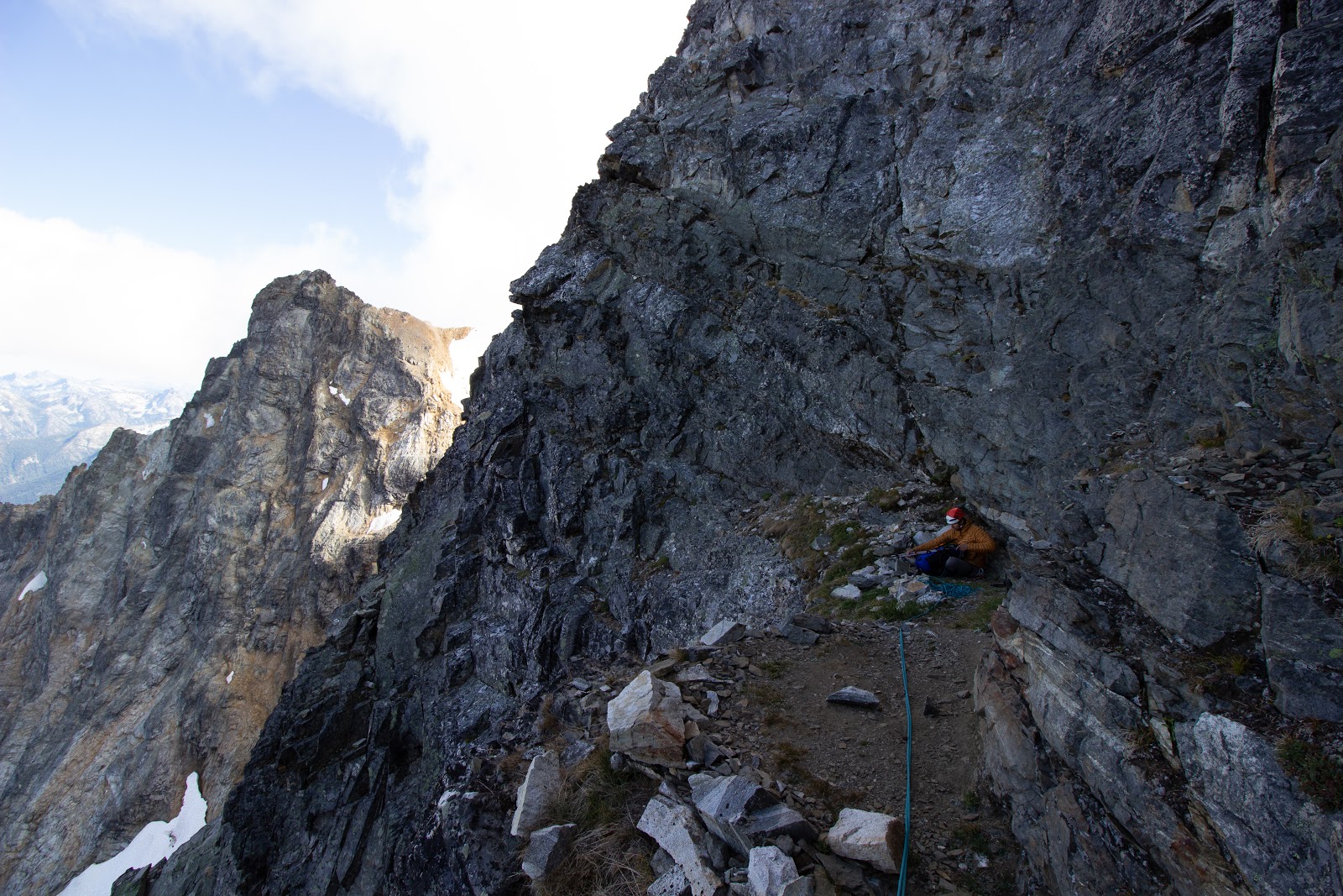
We traversed to the ridge crest on a ledge system of fairly loose rock. Once on the ridge the rock quality improved significantly and we enjoyed carefree scrambling up heathered ledges. Eventually the ridge steepened and we found ourselves too far left. We regained the ridge and climbed along the crest, simuling and occasionally belaying. Our rack of 8 nuts wasn't of much use in the generally parallel cracks, but the climbing was secure. We eventually made it to the bivy ledge and took a short break.

Logan and the source of the North Fork of Bridge Creek


Goode Glacier with Black Peak on the left

Taking a break at the bivy ledge

We climbed the ridge to the right of the bivy and found the rock solid and the climbing fun. We made it to the summit with a couple hours of daylight left. It looked like a spectacular place to spend the night, but we still wanted to climb Storm King and Logan so we used the last of the light to start the descent.


A glory from the summit of Goode

Buckner shrouded in clouds

Fernow and Bonanza

We made three rappels to Black Tooth notch, getting the rope stuck on the second one. Not wanting to climb back up, we built a 3-1 pulley with two microtraxions and pulled it free. We downclimbed past the first rappel station in the Southwest Couloir then made two rappels straight down. The first rappel we made was a full 30 meters and pulling the rope brought a lot of small rocks down.


Descending into the shadows

Rappelling into the Southwest Couloir
Photo: Nate Redon
We scrambled down the couloir and exited skier's left to avoid a cliff band at its base. It was getting dark, so we slid down some scree and found a nice bivy site next to a small stream at 7,700'.


Booker and Buckner at dusk

The night didn't feel much like summer. When the sun rose our bags were coated in frost and our water bottles frozen. I was glad that Nate had not wanted to sleep on the summit.


The morning after a cold night

We eventually emerged from our sleeping bags and started traversing talus towards Storm King. We emptied most of the gear from our packs and left our sleeping bags out to dry in the sun.

We worked our way up steep scree on Storm King's south face, followed an exposed ledge system around the north side of the mountain, and scrambled to the summit.

Scrambling across an exposed ledge on the NE side of Storm King
Goode from Storm King with the north face on the left
We scrambled back to the south side of the mountain and skied surprisingly enjoyable scree back to our gear.

Taking a break after descending Storm King

Agnes, Gunsight, Sinister, Glacier, and Dome

We picked up a climber's trail and followed it down a ridge southwest of Goode's summit. The trail is easy to follow until it enters the burn zone of the 2015 Goode fire. Here, we traversed skier's left to the edge of a large washout and eventually picked up a trail to the valley floor. A bit of bushwhacking brought us to the Park Creek Trail.


Fireweed dominates after the 2015 Goode fire

Ant versus inchworm: who will win?

We started up towards Park Creek Pass enjoying beautiful views and plentiful huckleberries along the way.


Feasting on huckleberries at Park Creek Pass. The resident marmot had obviously had his fill.

There were only a couple hours of light left by the time we made it over the pass. We filled our water and discussed whether or not we should climb Logan. Our original plan was to ascend the Fremont Glacier and descend the Douglas or Banded Glacier then exit via Easy Pass. Steph Abegg reported a massive barely-bridged crevasse on the Banded Glacier on August 2nd (2012), and we were pretty sure that it would have melted out this late in the season. We were able to see a some of the Douglas Glacier from Goode and it looked quite difficult to cross. If neither option worked our shortest way out would be reversing the Fremont Glacier, hiking 18 miles to Diablo Lake, and hitching a ride 30 miles back to the car. We were pretty sure that heading up Logan would end in Nate missing his first shift at work on Monday, so we decided not to do it. Oh well, I'll be back with my skis.

We hiked down Thunder Creek until the sun set and made camp. In the morning, we continued down Thunder Creek and then up Fisher Creek to Easy Pass.


Remnants of an old mine on the Thunder Creek trail

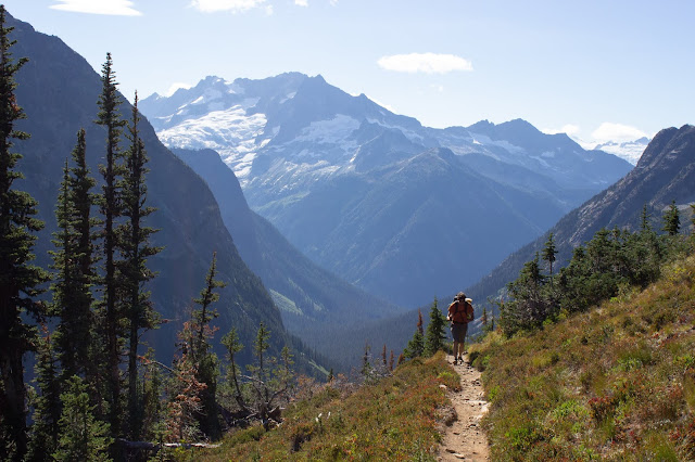
Hiking out Easy Pass with Logan and the Douglas Glacier in the background

We made it back to the car a couple hours before sunset. Biking over Rainy Pass sounded thoroughly unappealing so I tried to hitch a ride. There weren't many people headed east on Sunday evening, but eventually a really nice couple picked me up and fed me homemade cookies. It was the perfect end to an excellent adventure.

Gear notes:
 - Approach shoes, crampons, ice axes
 - 8 small nuts and 5 slings for NEB
 - 60m half rope, doubled for simuling

Sunday, August 19, 2018

A Weekend in the Pickets: Challenger and Whatcom

Challenger from Whatcom on the first ascent in 1936

Mount Challenger marks the northern end of Washington's most remote and rugged range: the Pickets. Phil Dickert (my great-grandfather), George MacGowan, and Jack Hossack were some of the first mountaineers to visit the area when they made the first ascent of Mount Challenger on September 7th, 1936. Not much has changed in the 82 years since their ascent. The terrain is still raw and wild, largely unmarked by trails, and infrequently visited.

My great-grandfather passed when I was young and I never got the chance to hear his stories or go into the mountains with him. Fortunately he was a prolific photographer, and I feel a connection to him through the photographs that he left behind. It has been my goal to repeat his first ascents for some time.

With just a weekend free and wildfire smoke choking the Northwest, a Pickets trip seemed unwise. But it didn't look like it was going to rain and Nate was stoked, so we decided to go for it.

We left Seattle on Friday night and made it to the Hannegan Pass trailhead at 10:40pm. We followed the route of the first ascent, hiking over Hannegan Pass and down to the Chilliwack River. The miles flew by as if in a dream; we were both stoked to wake up surrounded by terrain we had never seen before. We camped where Easy Creek joins the Chilliwack and got a few hours of sleep before the sun rose.

In the morning we easily forded the Chilliwack and followed a trail up series of switchbacks to Easy Ridge, where we found fields of ripe huckleberries. We hiked along the ridge as a strong wind brought smoke in from wildfires in the east. A descending traverse to the toe of a steep buttress brought us to an abrupt slot canyon known as the Imperfect Impasse. We found an easy traverse into the canyon by scrambling up grassy ledges from the toe of the buttress, then climbed out into a stunning cirque and made our way up talus and granite slabs to Perfect Pass.

Getting some water on Easy Ridge

The Imperfect Impasse

Perfect Pass

A mama Ptarmigan. Not pictured are her two chicks

The massive Challenger Glacier sprawled out in front of us. We made a high traverse and eventually gained the Challenger Arm, then continued up weaving through massive crevasses. We crossed the infamous bergschrund on a solid bridge and climbed a steep snow arête above.

Traversing the Challenger Glacier on the first ascent

Nate climbing above the bergschrund

Summit of Challenger on the right

We traversed to the summit block and scrambled over loose blocks to the base of the final corner. I led a short pitch protected by a couple pitons, possibly from the first ascent.


Challenger's summit block

Climbing the summit block on the first ascent

Smoke obscured most of our view into the Pickets, but added to their mysterious and intimidating aura. I'll have to come back on a clear day to fully appreciate the view.


The ridgeline south of Challenger looks quite intense. Maybe someday...

Sub-peaks of Challenger to the east

We rappeled the crux corner and made our way back onto the Challenger Glacier. I downclimbed the snow arête while Nate scrambled down good rock to the east.

We traversed to investigate a strange object that we had seen on the way up and found that it was a  dead turkey vulture. Why it was so deep in the mountains I don't know. Perhaps it was fleeing from wildfires in the east?

A turkey vulture high on the Challenger Glacier

We retraced our ascent back to Perfect Pass and made it to camp as the sun set.


A precarious snow bridge

The lean winter of 2014-2015 is clearly visible on the right side of this crevasse

Traversing the Challenger Glacier to Perfect Pass

Smoke made the night warm and the morning cold. We woke with the sunrise but slept for another hour until the sun's heat could reach us through the smoke.

Not convinced that we had achieved full value, we decided to climb Whatcom Peak and exit via Whatcom Pass instead of reversing Easy Ridge.

The south side of Whatcom from Challenger

We climbed easy snow up Whatcom’s south side then scrambled up the pleasant south ridge to its summit. It was clear that it was too late in the season to easily bypass Whatcom to the east, so we decided to descend the North Ridge. We tried picking our way down the NE face to avoid the steep and exposed upper ridge, but found the rock to be of terrible quality and returned to the ridge crest. We downclimbed an exposed knife edge on decent rock, which was the crux of the descent. The angle lessened afterwards, but the rock was loose enough and the position serious enough to keep the descent engaging. We felt quite stupid for not bringing helmets.


Nate high on Whatcom's North Ridge

The impressive Whatcom Glacier

Looking back at Whatcom through the smoke with the North Ridge on the right

We eventually made it down to a snowfield on the ridge and lower angle terrain below. We followed the scenic ridge back to the trail at Whatcom Pass. I felt a sense of relief knowing that we were done with Whatcom's choss and just had 17 trail miles back to the car.

From Whatcom Pass the trail follows pristine streams down to Brush Creek until it joins the Chilliwack River. We took a hand-powered cable car across the Chilliwack then followed it up to Hannegan Pass and made it back to the car at dusk.

Out of the smoke

Nearing the end of Brush Creek

Cable car across the Chilliwack!

Many thanks to my aunt Judi Lemp and Lowell Skoog for preserving these photos. They have given me a ton of inspiration and I hope that they will inspire generations of Cascade climbers to come.

Sunday, July 29, 2018

Torment-Forbidden Traverse


The Torment-Forbidden traverse negotiates a complex ridgeline of rock and snow on one of the most spectacular massifs in the Cascades. The climbing is easy, but there are enough alpine challenges to keep it interesting.

Torment (left) and Forbidden (right) from Boston Basin

Matthew and I woke up at 5am at the Cascade Pass TH and hiked up to Boston Basin. We traversed to the base of the Taboo Glacier and made a spicy moat crossing onto the S ridge of Torment. This can be avoided later in the season by crossing the S ridge of Torment at 6,600' and then gaining the S ridge from the Torment Basin side.

Matthew following the moat crossing. We crossed just below the bergschrund.

We climbed the left of two loose gullies to gain the S ridge, tempted by a fixed line. I took a nice rock to the head, cracking the back of my helmet. The right gully looks like a better option.

We soloed the S ridge of Torment and then scrambled up the SE face to the summit.

Traversing the SE Face of Torment

Forbidden from the summit of Torment
We scrambled back down Torment's SE face to a break in the ridge, then made an overhanging rappel onto the N side. I rappelled into a moat and climbed back out, chimneying between the snow and rock. Matthew followed as I held the lines so that he wouldn't have to rappel into the moat as well.

A gaping crevasse split the slope below. We climbed into the moat on the right and found a rappel sling.

Rappelling to bypass a large crevasse
Traversing the rock rib. This is the first decent bivy.
We continued traversing to the right and climbed over a well-bridged moat back onto the rock. We did a rising traverse to near the top of the rock rib and then gained a snowy col.

Approaching the steep snow traverse
The snow had been baking in the sun all day and was in great condition, so we decided to do the steep snow traverse instead of the rock bypass. It was casual in approach shoes with crampons and an ice axe.


Photo: Matthew Koppe

We transitioned to the south side of the ridge and found the halfway bivy site. It was still early in the day so we decided to continue after making some water.

Resting at an excellent bivy site halfway along the ridge
Eldorado, Klawatti, Austera, Primus, and Moraine Lake below

We stayed on the south side of the ridge on easy terrain, where I took a nice fall off of an unstable boulder. I was a bit scratched up, but thankful that I had fallen here instead of anywhere else on the ridge, where a fall would have been much more serious.

We traversed along an exposed knife-edge section of the ridge then skirted down a 4th class ledge system to the base of the West Ridge of Forbidden. In hindsight, we could have taken a more aesthetic line on the ridge crest, although this line may require a rappel.

Traversing the knife edge section. There are nice ledges on the N side.
Photo: Matthew Koppe

We found a beautiful bivy just above the col on the north side of the ridge. We rested for a while, trying to decide if the thunderstorms in the east were coming towards us or not. They didn't look too threatening, so we decided to climb the West Ridge of Forbidden.

We simuled on a doubled 6mm rappel cord, which didn't inspire much confidence. I wouldn't use this system if the climbing were any harder. Matthew led around the crux gendarme on the left without much difficulty. I led us to Forbidden's eastern summit.

Matthew on Forbidden's summit with Bucker on the left

Boston, Sahale, and the Quien Sabe Glacier
We climbed to the western summit, then downclimbed to a pitch above the crux gendarme. We made two 30m rappels, the second of which took us onto a ledge system on the north side of the ridge. We stashed the rope and soloed back to our bivy site as the sun set.

Back at the bivy as the sun sets over Eldorado
Thunderheads over Boston and Sahale illuminated by the sunset
We made some water and went to bed. The night was calm and warm; the position spectacular. 

Sunrise to the north
We woke at sunrise but spent a while enjoying the morning. All we had to do today was descend and we were in no rush to leave this spectacular place.

Eventually we scrambled down to the south and rappelled a rock rib just west of the main approach gully. After 7 rappels we made it down to the snow. We glissaded and boot skied down to the rocks and found a beautiful slab of rock to chill out on.

We sunbathed for a couple hours, admiring the ptarmigans and marmots. It's a magical fairy land up here!

Three marmots with the Triplets in the background
Mama ptarmigan
Baby ptarmigan
Our original goal was to climb Boston and Sahale after completing the Torment-Forbidden traverse, but it was hard to get stoked on the choss of Boston. We were also out of food, so we decided to descend instead.

Matthew sending a creek crossing on the descent